Friday, September 29, 2006

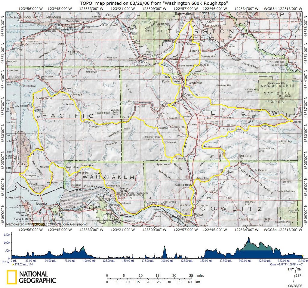
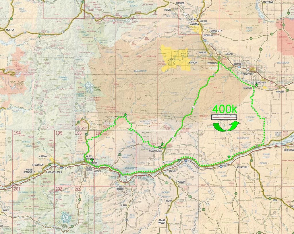
6/25/2006 -- Barlow Trail Century, 120 miles

The Barlow Trail Century is my favorite organized ride. The 2006 edition was the third iteration, and my third time doing it. It's a little on the expensive side, at $35 to pre-register, but it's a fundraiser for Bicycles and Ideas for Kids Empowerment, so the money goes to a good cause. Plus, the food and support is absolutely top-notch, culminating in awesome tasty burritos and local microbrew at the finish line.

It's also kind of a tough ride, with about 7000' of climbing, total, including an ascent up Lolo Pass on the northwest corner of Mt. Hood. But it's a beautiful route that goes the way it does for good reason; I love the Torture 10000, too, but the route kind of tries a little too hard to pack in the elevation at the cost of not really feeling like it's going somewhere. With Barlow, getting to the top of Lolo Pass feels like it's an accomplishment, and the ride out and back feels like an epic -- all of the climbing is for an ultimate purpose, none is gratuitous.

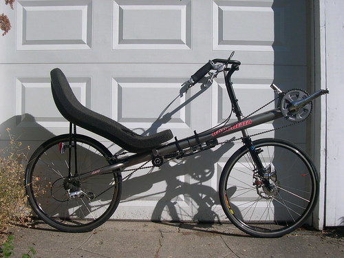
I finally convinced my buddy John Climaldi to join me for the ride this year. John and I are an excellent team for brevets and fast recreational rides, we're fairly well matched, strengthwise, and we ride similar platforms (John on a Carbon Aero, me on a Ti Aero). He's also good company for the long haul. Also, I knew he'd get a kick out of the course and scenery.

I rode from my house to the start at Paesano Park, and met John. We made some last-minute bike adjustments, and promptly hit the road. Actually, bike path. The route starts out on the Springwater Corridor, and goes to the end of the pavement, just outside Boring. Then it gets on some secondary country roads to Dodge Park Boulevard. There was a slight amendment to the route this year, so I ended up leading JC somewhat off the path to a gas station on Orient Road which had been on the route in previous years. (Just as well, as I needed to find a restroom.)

We followed Dodge Park Boulevard to Lusted Road, and took that down through the wooded switchbacks to the Sandy River, and then up the other side. We were at the first rest stop at Bull Run School in no time, and we met up with fellow OHPV'ers Joe Keenan and Marilyn Hayward. We chatted for a little while, and then pressed on. The day was really heating up, and we wanted to get some climbing out of the way before the sun got too high.

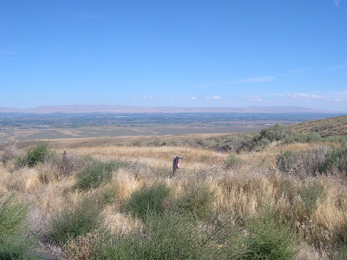
Out of Bull Run, we got on Shipley, which was a gently climbing, winding road with plenty of shade from the surrounding alder trees. When Shipley ended, we turned onto Marmot Road, which took us along a ridge called the Devil's Backbone, so named by pioneers who hauled their wagons up the ridge after taking the Barlow Road across the mountain. The top of the ridge included fir forests and horse pastures, and gave us occasional glimpses of the mountain.

After rolling along the top for a couple miles, the road plummeted down through the trees and before we knew it we were out in a clear alpine valley, threading our way between hay fields, with the mountain rising above the hills in front of us. Little Switzerland. I started singing "The hills are alive with the sound of muuuussiiiic" in my campiest falsetto.

A few miles later, we entered the dry pumice-y forest of pines and firs to the north of the Sandy River, in the area around Brightwood. Here, the Barlow Road blessed us with almost brand new, smooth pavement, as it gradually climbed up the valley past the occasional vacation cottage. Before we knew it, John and I were at Lolo Pass Road, ready to start the day's big climb.

There was another rest stop there, though, so we took advantage. We loaded up on fresh fruit and berries, grabbed a cookie or two, and refilled our water. Then we began the big push up to the pass.

The climb up to Lolo Pass is on a small, twisty forest service road that switches back and forth, winding along the edge of the hillside. The grade varies greatly, going from 5% on up to 15% or so for short stretches. Fortunately for us on that hot day, it was almost entirely shaded. I left John behind because I wanted to see what kind of shape I was in, to really test myself against that climb, whereas John took a more relaxed approach to it.

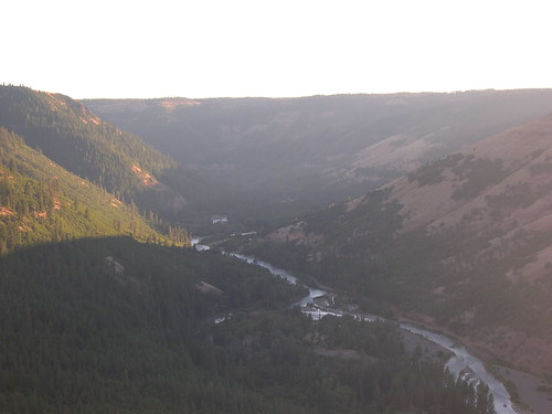
We met again at rest stop at the top of the pass, where it was pretty much a party. There was all kinds of great food, from the traditional fresh fruit and breads to ravioli and italian sausage. There was also a beautiful view of the peak from the pass, and John and I got our picture taken.

It was really heating up by that point, though, so after resting and refueling, we got rolling, looking forward to the 12 mile descent off of the pass that was in front of us. The road down is different from the road up, and much better suited to a high-speed descent. It was a white-knuckler, and the Aero handled it like a champ. Though I made a couple questionable judgements, and had to feather the brakes a bit when I went into a couple of the corners a little too hot.

We regrouped at the junction with Barlow Road, and then sailed along back down that sweetly paved road at 26 mph while hardly breaking a sweat. The route is mostly out-and-back, which gave us the same scenery from a new perspective, but it was so nice the first time that we weren't at all unhappy to get it again. We started climbing again at Little Switzerland, and then there were a couple steep pitches as we scaled the Backbone from the opposite direction. The heat was in full force by that point, and I think John and I were really feeling it. But the rollers at the top went by easily enough, and then we were sailing back down towards Bull Run. We stopped briefly when John got a flat, and I realized just how much I craved speed when the sweat on my body stopped evaporating quite so quickly.

We watered up at Bull Run, and then went down the to river, up the other side, and wound through the country east of Boring. At that point, my strength was somewhat down, and I was in my "keep pedaling" mode. But in Boring, a sweet couple was giving out popsicles from a roadside awning. Oh MAN! Talk about hitting the spot on a hot day! That little frozen chunk of fructose was plenty to refresh us and power us back the rest of the way to Paesano, and then home.

This is a great ride in and of itself, and the organized version definitely adds a lot of value over just riding it on your own (but that is fun, too). But another great aspect of it is that it is a wonderful way to get onto Mt. Hood without having to ride on Highway 26. Furthermore, once the Barlow Road ends, and you find yourself near Zig Zag on Lolo Pass Road, there are a number of really nice campgrounds that very easily accessible. This is a very reasonable (though somewhat challenging) ~60 mile ride from east Portland -- well within what most touring cyclists are comfortable doing in a day.

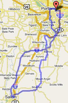
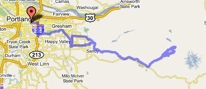
Here's a link to the map of the route on gmaps.

Monday, September 18, 2006

9/16/2006 to 9/17/2006 -- SIR 600k Brevet, 400 miles


I did SIR's (Seattle International Randonneurs) 600 kilometer brevet this weekend. I rode it straight through, with no breaks for sleep.

It was the hardest thing I've ever done. No joke.

My original plan was to ride to the overnight control, get 5 or 6 hours of sleep, and then finish up the ride the next day. As the overnight control was about 380k into the ride, I figured that would end the first day well before midnight, giving me plenty of sleep time. I could then get up before dawn and knock out the remaining 135 miles pretty easily.

I talked with experienced randonneurs, though, and they suggested going straight through. As it turns out, I will be doing an ultracycling race in 3 weeks, The Furnace Creek 508, and they thought it might be good for me to get a feel for what I'm in for.

So I showed up at the start planning to make a straight shot of it. There were about 35 of us gathered there in the Motel 6 parking lot in Tumwater, and I was the only one on a 'bent (my brevet-configured Aero). Six o'clock rolled around, and we pedalled off into the cold, foggy morning.

We negotiated a couple of quick turns, but soon found ourselves on Littlerock road, which took us out into the country surprisingly easily. The road was flat and true, and took us to an un-named suburban community between Olympia and Centralia. Beyond that, the route put us on small back roads that did more winding around (and especially over) hills. The thick darkness tentatively let go of the morning, replaced by a thick fog. The winding road took us through charming, lush nooks and hollows, past green pastures nestled in the trees between hills, and along quiet brooks.

On the outskirts of Centralia, the Tolkien-esque landscape was replaced by broad, flat agricultural vistas. Over a few more rollers, and I found myself in Winlock, Washington, home of the world's largest egg. From there, it was south on the familiar StP route to Vader, location of the first control. A rest, a snack, a stamp, and I was on my way.

From Vader, the route continued on roads that were quite characteristic of the coastal mountains here in the northwest. Lush green valleys and forested hillsides with the occasional clear cut. I was on backroads to Pe Ell, where I got on SR 6, which was a more major road, but still very quiet, and with a decent shoulder for most of its length (the shoulder did disappear a few times, though.) I crested an easy, early summit, and pushed through some inconsequential headwinds all the way into Raymond, the location of the second control, where I took another break. I considered briefly that I had done 112 miles on the day, and what was in front of me was still longer than the longest ride I had ever done. Then I tried not to think along those lines any more.

I had to deal with a flat tire on my way out of town, but soon found myself rolling south along Willapa Bay on highway 101. The country for this section was rolling, as I was crossing rivers and streams that drained into the bay. There were also frequent stretches that put me right up next to the water. My favorite section of road was right after the junction with SR 4, a lonely section of highway near the Willapa Bay Wildlife refuge. The combination of the water, the hills, the trees, the distant islands, and the solitude of the place was terribly atmospheric. The miles into the third control, Long Beach, went by easily.

In Long Beach, I got some more food, and took another break. I definitely knew that I had done something that day. I was starting to feel some fatigue. But my joints and muscles felt pretty good, and I felt comfortable that I was doing a good job staying on top of my eating. So, I ate some more, got back on the bike, and pedaled on out of town.

South to Ilwaco, and then east along the mouth of the Columbia River. Lewis and Clark country. World War II era coastal defense country. Along the riverside, past the Astoria Bridge, and then inland to Naselle, through a sweet and tidy coast range valley. Up over the inscrutably named K-M Mountain, and then down to Cathlamet. There was supposed to be a feed stop before the climb, but I was too fast; they set up after dark, and it wasn't until Cathlamet that night had really fallen on me, so I took a stop there to eat. The road after Cathlamet wound along the riverside, on a narrow ledge. At one point, I looked to my right, out over the river, and saw a freighter heading up the channel close enough to touch! She was going almost exactly the same speed as I was, 17 or 18 mph, and so we traveled together for several miles. I think I even saw a crewman out on the deck looking my way, trying to discern what my strange configuration of lights signified.

Other than that, the stretch between Cathlamet and Kelso was a lowlight (no pun intended). Darkness had fallen, but it wasn't late enough yet that the traffic had really fallen off. Plus it was a narrow winding road, making for some nervous riding. Still, I pulled into the overnight control just after 10, feeling none the worse for wear.

It was really cooling off, and the folks at the control were angels. Unfortunately, I had just eaten at Cathlament, and wasn't really at a good point to eat much again yet, so I didn't really take full advantage. I did call my girlfriend Jennifer, though, and let her know that I had made it, that I was all right, and that I was feeling good. She was clearly worried about me -- she could hear the fatigue in my voice -- but helped me get up the courage to plunge back out there into the thick, cold night.

It was hard to go out again into the night, and even harder when I found that I had another flat tire. Like this needed to be any harder. But I patched it, and made sure my spares were in order (didn't want to be waiting for a patch to dry in the event of another flat!), and set out. It was drizzling as I pushed north on SR 411.

I could give you a play by play of what I remember of each turn and every hill in my night ride, but I don't think that would tell very much. It was generally uphill (including a couple stiff climbs) to the control at Toutle, and then there was some descending and drainage crossing down to Toledo, and finally a major prolonged climb up to a summit above Morton that ended with a screaming descent down into town. That doesn't really capture what I was up against, though. Riding alone at night, in the cold, in the drizzle, through the woods and wilds, with not a single other soul for company is paradoxically both soporific and existentially terrifying. There is very little that communicates the reality of an uncaring universe as effectively as being out on an empty highway, passing through tiny towns where all the lights are out and everything is closed, in pitch blackness. The night was mostly overcast, so I didn't even have the stars for company. And at the same time as my own cosmic insignificance was being bludgeoned into me, my body's response to the late hour and the low light was to make it almost impossible to stay awake. It was like being sung a lullaby by your executioner.

I did finally make it into Morton, a much smaller person than I was when I left Kelso. It was right around 6 AM when I pulled in, and it was easy to find an open mini-mart. I ate a breakfast sandwich, I sat in a booth, and I let myself doze off for a few 10 second naps. That was all the sleep I could manage under the circumstances, but between that and the lightening sky, I found the energy to get back on the bike and keep it pointed straight. I headed out of town on SR 508, which wound through the Tilton River Canyon.

I felt better, and I had elevation to burn. SR 508 did not disappoint on that score; though there were a couple climbs as the road went along the hillside, the trend was quite discernably downhill, and my speed and ease of travel was commensurate. I covered the next 20 miles in a hurry.

I then turned onto the Alpha-Centralia Road, which announced its intentions right away by beginning with a short, steep climb. The road's 20 miles into Centralia were generally descending, but punctuated by long, sharp drops into drainages, followed by climbs up the other side. Not typically terrain that I shy away from, but my body and spirit were in no shape for this kind of tussle. I just kept pedaling, that was all I could do.

Centralia finally came, and my spirits lifted. Feeling comfortable with my ability to estimate my final arrival time, I stopped at the train station to buy a ticket from Olympia back home. Then I pressed on, heading north on the comfortably familiar SR 507, back on the old StP route through Bucoda and Tenino. In Tenino, I got onto Old Highway 99, and wound through the forest, farms, and residential areas south of Tumwater. Around the airport, and back onto wide (though empty, at this hour on a Sunday) streets, onto the I-5 frontage road, and back to the Motel 6. I signed my brevet card and turned it in, knowing for the first time exactly what it takes to earn the designation, super randonneur.

I completed the ride in 28 hours, 49 minutes, finishing at 10:49, Sunday morning. Official course distance was 375 miles, but navigational errors and the ride to the Olympia train station after I completed the event added enough additional mileage to get me to 400.

Details about the ride and a complete cue sheet are available at the Seattle International Randonneurs' site, here.

Wednesday, September 13, 2006

9/9/2006 -- Klickitat Explorer 400k Brevet, 250 miles

People interested in this blog should either already know about randonneuring or get to know about it. Randonneuring is a wonderful non-competitive sport that involves riding one's bicycle a very long way. The original idea when the sport was devised was to demonstrate the distances that were attainable in reasonable lengths of time by the combination of a person's muscle power and a bicycle's mechanical advantage. To that end, randonneuring events (called randonnees or brevets) come in 200, 300, 400, and 600k lengths, and must be done within a specified time limit (typically around 15 kph). The rider who completes this cycle then has an opportunity to do a grande randonnee of 1000 or 1200k, if he is up for it. The randonneur has a card that he gets signed at various control points, which verifies that he has ridden the entire route.

The best part about randonneuring for me is the opportunity it gives me to share the road with fellow long haulers, even if our mis-matched capabilities and platforms mean that we only share our company for a limited time. There is a camaraderie and an esprit de corps that in many ways is even stronger than it is among racers, because of the massive challenge of the longer events and their non-competitive nature. Everyone who finishes is an equal, and riders take pride in keeping the DNQ rates as low as possible.

Which brings us to the Klickitat Explorer 400k. This ride was organized by John Kramer, and was the second 400k event put on by the Oregon Randonneurs this year. In many ways, the 400k is considered to be the most difficult distance of all brevets in the regular series -- the distance is daunting for a single day, but the time control is 27 hours (not long enough to take a whole night off), so there is no way to avoid a fair chunk of night riding. (Obviously, the 1000k and 1200k events are daunting for the sheer magnitude of the distances involved.)

We set off from Bingen, Washington, at 5:00 AM under the silver light of a full moon. The wind was already freshening at my back, and after I wound the cranks up, I found myself flying low along Washington's SR-14. I've now ridden eastbound on both sides of the Columbia as it borders Oregon and Washington, and I must say (though it pains my provincial heart), SR-14 is vastly superior for cycling -- good shoulder, low traffic, beautiful views. Good surface for most of it (though we did have a couple stretches of chipseal). The only complaint was that the road is somewhat hilly, but even so there were no particularly difficult grades.

I arrived at the first control 4 minutes after it opened, and so felt very good about my pace so far. I knew, though, that this was the flat section with a tailwind, and that the real work was ahead of me. This pace was going to be the exception today, rather than the rule. So I ate a ham sandwich and drank a pint of chocolate milk, and was on my way.

A few more flat, wind-assisted miles along the gorge, and then it was time to get down to work. The route turned north up Alderdale road, which started out winding up out of a creek cut, and then seemed to level off on a smooth plain. The road zig-zagged the to north and west, and soon I got a taste of what kind of wind I'd have to climb my way out of for the rest of the day. The wind didn't seem too bad, but yet I was working hard to little perceived effect. The plains that the road wound through were deceptive -- the lack of actual "hills" disguised the fact that I was climbing up a pretty good grade!

When I got to the top, I could see just how much elevation I had gained. Looking down, I could see the Yakima River Valley, and the town with the next control point, Mabton. I sped down the hill, checked in at the control, ate, replenished my water, and was soon on my way.

The next stretch of road was described as "flat as a pancake." A flat, but very rough pancake. With plenty of contrary wind. 19 miles to Toppenish seemed to drag on interminably. Then I turned southwest on US 97, to tackle the major climb of the day.

97 between Toppenish and the top of Satus Pass wasn't a bad road, but there was plenty of traffic and a shoulder that came and went. The road followed a creek grade through dry hills typical of the northwest United States east of the Cascades. The ground around the creek was a lush oasis, and climbed very gradually. But about 5 miles from the top, the grade increased, and it was all business the rest of the way up. After a brief descent, I pulled off the road at Brooks Campground to check into the next control.

A quick break, and I got to enjoy the fruits of my labors, as I had a fairly easy and quick descent (though still impeded by the headwind) down the other side of the pass to Goldendale. In Goldendale, the route turned west, and spent about 20 miles on some pretty unpleasant rollers. Normally, I'm way cool with rollers, but the headwind was preventing me from getting up the momentum I need to really tame them.

Then, as all things must when you keep pedaling, the rollers ended, and I found myself at the top of the Klickitat River Gorge. An absolutely stunning, surprising sight that just took my breath away when it emerged around the corner. I was incredibly grateful to have been strong enough to get there before the daylight ended, both to be able to see it, and to have the light for the twisty descent down to the river.

Of course, what goes down, must come up, but aside from a short, stiff section just on the other side of the river, the climb back out was surprisingly painless. I soon found myself at the final control in Glenwood, near the base of Mt. Adams. I took a break there, letting my legs recover and taking in some fuel for the home stretch, and when I emerged to tackle the last 30 miles, the dark of night had fallen.

Fortunately, the twin E6 lamps on the front of my Aero lit up the road with aplomb, and I was able to navigate the dark country roads unerringly. There was very little to see, naturally, but at one point I did look towards the horizon on my right, and noticed an owl flying along with me against the backlit sky. This final leg featured a heaping helping of elevation loss, and I got the bracing experience of a fairly high-speed descent down to BZ Corner. Then it was just a matter of winding through White Salmon, down the hill, and back to the start point for a 7up and a nice hot bowl of ravioli, finishing 17 hours and 1 minute after I started.

I've put up some pictures from the ride on my flickr site.
I haven't done a google map of the route, because John Kramer did the nice jpeg map that I've attached. If anyone needs more detail than that provides, I believe there is a cue sheet on the Oregon Randonneurs site.

Wednesday, September 06, 2006

The Stable

I've got a few personal mottos, one of which is: more bikes equals more happiness. I don't drive, which not only keeps me in shape, but lets me feel free to be as extravagant as I want with my human powered vehicle collection.

My current collection of bikes numbers 7, including such exotics as a Brompton, a Santa Cruz Blur with Jones Bars, and an M5 Carbon Lowracer. Those are all bikes with rather narrow specializations, though, and I would like to introduce you to the bikes I use for the Long Haul. I'll do so over a few posts, and I'll start with a bike that I have great deal of love for, my Bacchetta Aero.

William Tell

William Tell is my custom titanium Aero, generously supplied by my sponsor Bacchetta. I've pretty much customized every component on it, with the exception of the headset, brake levers, and rear brake. It is shown here in brevet configuration.

The Aero is a wonderful, versatile bike. It's handling characteristics are everything you could ask for; I've ridden major miles on 3 different highracer designs, and Bacchetta's geometry blows them all away. The bike has turned me from a mediocre descender into an enthusiastic one. It is simply planted in the corners at the same time as it swoops through them. The bike is also slippery as all getout.

As I say, it's versatile. In its brevet configuration, it features a Schmidt hub with twin E6 headlights, an Avid disc brake, and (soon) fenders. Outfitted thusly, it is perfect for the long night miles and lousy weather that one can frequently encounter on brevets. With the addition of Radical bags, I have even done light touring on the bike.

At the other end of the spectrum, the bike is quite a capable racer, and in its race configuration, weighs in at right around 22 lbs. I don't keep it in this configuration as a rule, but when I need to break out the secret weapons, the Aero sports a carbon fork with a caliper front brake, HED Alps wheels, 23 mm tires, and a closely spaced 11-23 Dura Ace cassette. Doing most of my riding with the heavier equipment makes the bike feel much faster when I break out the high zoot stuff, and preserves expensive gear at the same time.

(The picture above is courtesy of Joey Grimaldi.)

To facilitate re-configuring the bike, I've used a combination of a DaVinci cable splitter on the front brake and TerraCycle cable guides/stops on the stem riser. This lets me switch front forks by simply loosening two 5mm allen bolts and unscrewing the cable splitter, sliding the new fork in, tightening the bolts and headset, and connecting the brake cable on the other fork (which has its own half cable that ends in a splitter) up to the half cable attached to the brake lever. Since the front fender, the cable disc brake, and the lighting system (the hub, wiring, and lights are all contained by the fork) are all entirely of a single piece with the brevet fork, it makes completely changing the character of the bike a snap.

Here's the complete component spec for William Tell:
Shimano R700 compact crankset (50/34)
Shimano Dura Ace bottom bracket
Shimano Dura Ace front derailleur
Shimano Dura Ace rear derailleur
Shimano Dura Ace bar con shifters
SRAM PC-89R chain
Terracycle over/under idler
Avid speed dial SL brake levers
Bacchetta dual pivot calipers
FSA Orbit headset

Race configuration adds:
Shimano Dura Ace cassette (11/23)
HED Alps wheels
Michelin Pro Race 650x23 tires
Speedplay X5 pedals

Brevet configuration adds:
Harris Cyclery High & Wide cassette (11/28)
CXP-33 wheels w/ 105 hub (rear) and Schmidt hub (front)
Avid BB-7 disc brake (front)
Terry Tellus 650x28 tires
Crank Brothers Eggbeater pedals

You can see pictures of my long haul bikes in this flickr gallery.

Monday, September 04, 2006

8/27/2006 to 8/28/2006 -- Salem, 130 miles

While the coast, the gorge, and Mt. Hood represent the glamour destinations for Portland cyclotouristes, Salem is an afterthought at best. At first, it doesn't make sense: the ride is an easy, flat 65 miles, there are plenty of beautiful and low traffic roads from Portland down to Salem, and the town is large enough to provide all of the services that a bicycle traveler could want. So why don't Portland cyclists frequently hear of two or three day excursions taken by riders down the valley to our state capitol?

The answer is very simple: Salem provides no good answer to the question, why bother? Generally, there really isn't any good reason to make the trip. Salem doesn't have any particular attraction, and while the ride down the valley is first rate, actually riding through the outskirts of town consists of your typical 5 lane highways and strip malls. Earlier this summer, though, I got wind of a concert that would take place at the state fair that I thought would be really fun to see (The Decemberists, The Violent Femmes, and Cake). So I brought up the idea of taking the weekend and riding down there with my friend Jeme, and we made our plans.

Let's go to the fair!

Since Jeme is an upright rider, and since this was his first loaded bike trip, I thought that it would be good to show some solidarity with him, and to ride a bike that would let us be relatively evenly matched. For this reason, I selected my Rivendell Atlantis for the trip.

Jeme and I got a late start, and proceeded south on the Oaks Bottom bike path under the warming sun. We found our way through Sellwood and Milwaukie to River Road, and took that to Oregon City. From there, we crossed the Willamette River to West Linn, and took Willamette Falls Road through the historic downtown and around Pete's Mountain to Turner Road, which we took over the hill's shoulder. Turning onto Mountain Road, we had a fun set of descending rollers all the way down to the Canby Ferry, which took us back across the Willamette River to the town of Canby.

From Canby we went south, through country that I knew well from day rides that I've done with my friends Bruce and Bill, who live in the area. We pedalled through Lone Elder, and took secondary roads such as Gribble and Zimmerman to Meridian Road, which runs up the spine of Elliott Prairie from Aurora to Silverton. Meridian is a wonderful road, with long lines of sight, little traffic, easy grades, and nicely spaced opportunities to buy refreshments at Whiskey Hill and Monitor.

In the charming little town of Silverton we took a rest break in the city park. Then we headed southwest out of town past the Oregon Garden, but I had us turn west one road too soon, and we found ourselves on the Silverton-Salem Highway. I had hoped to take secondary roads on this leg, but it was the part of the ride that I was least familiar with. The main road was fine, though, with plenty of shoulder and traffic that was reasonably light (6 cars per minute or so) and not overly fast. It also took us almost right to the doorstep of my friend Keith's house, in whose yard Jeme and I were to camp.

The fair was something of an alien cultural experience, and I got more than enough of it in the 90 minutes we had to look around before the show. The concert was great fun -- The Decemberist's new album should be excellent, judging from their new material, and Cake was in fine form. It was a little painful to watch the poor Femmes play the same 10 songs they've been playing for the last 25 years, though.

The next morning we packed up and headed north on Cherry and then River Road out of Salem (different River Road). This took us very cleanly out of Salem and then Keizer, and soon we found ourselves on French Prairie, rolling through fields of hops. The wind was contrary, so I let Jeme sit on my wheel all the way up to Champoeg park -- the birthplace of Oregon's state government. It was a straight shot all the way up from Salem.

We took a moment in the park to enjoy the Willamette River, and then took the park's bike path through the woods to Butteville. From Butteville we proceeded on Arndt and Knight's Bridge Roads into Canby, a route which was very familiar to me from the Portland Wheelmen's Spring Century. We got onto Territorial in Canby, rode to 99E, and took South End Road over the hill back into Oregon City. Just past Oregon City, we crossed the Clackamas River, and Jeme decided that the water simply looked too inviting to pass up, so I bid him farewell, and proceeded up the I-205 bike path back home, concluding a fun trip.

This expedition is a great illustration of the best options for accessing the Willamette Valley from East Portland. The first step is to get to Oregon City, and my favorite ways to do that are to take the Oaks Bottom Path and River Road, or the I-205 path. (Another option would be to take Terwilliger from downtown and 43 from Lake Oswego.) From Oregon City, Canby is a logical next waypoint, and both the West Linn-Turner Road-Canby Ferry route (for the scenery) and the South End-Territorial Road route (for speed, if you can manage the steep climb out of Oregon City) are good ways to get there. Finally, to go further south, you almost can't go wrong with any secondary road in the valley, but for my money, Meridian Road and French Prairie Road/River Road stand out because of their directness and the sheer amount of ground they cover.

Here is a link to the route on the google maps pedometer.
Here is a link to my photos on flickr.