8/27/2005 -- Mt. Hood, 160 Miles
If there wasn't already a local ride called "The Big Lebowski", I think this one would be a good candidate for that moniker. What could be a bigger Lebowski than completely circumnavigating a mountain, including bagging 3 of its passes?
I got a chance to do this ride for the first time late last summer, and enjoyed it immensely, both for the sheer challenge of it, and for the wonderful roads that I got to explore along the way. This is definitely a ride that I will be returning to (though at the moment there's a fire in the Elk Meadow area that has closed highway 35 up to Bennett Pass).
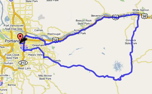
I started out by heading out of town on Marine Drive, enjoying the smooth, level road to Troutdale. Then I went up the Historic Columbia River Highway, over Chanticleer Point, and down through waterfall country. These roads are the bread and butter of most Portland area riders, but it was fun to go out on them knowing that I'd be coming back a different way.
Finally, past Warrendale, I had to get onto I-84 for about 2 miles. Not the most fun road in the world, but plenty of shoulder, and not too much trash. Supposedly, Congressman Peter DeFazio is looking into funding enough connections to make it possible to pedal from Portland to The Dalles without having to go on 84, which would be lovely. Truth be told, it's not a terribly challenging project, actually, as there are only two gaps left that I know about (more on the second in a moment).
I got off of 84 at Bonneville, and got on the 6 mile stretch of the HCRH that is only open to bike and pedestrian traffic, which I took into Cascade Locks. Through town, onto Forest Lane (pretty much a frontage road), and then Herman Creek Road. Not overly scenic (although there's always something pretty to look at in the gorge), and not quiet (next to 84), but very little traffic, so good enough. Finally, Herman Creek Road ended, and I had a choice to make: either get back on the freeway, or turn right to take a back road on over to Wyeth, which I wasn't very knowledgeable about.
Being an adventuresome soul, of course I took the road to Wyeth. Nice road, but very steep. Lots of false summits, and each time the climbing resumes, it comes back steeper than before. But it kept me off of 84 for a few miles, and got me some very nice scenery. Finally, though, I had to get back onto the freeway for the last pull into Hood River.
The stretch of freeway between Wyeth and Hood River is pretty hairy. It's 12 miles, and there is a hair-raising half mile or so where the shoulder gets a lot narrower than I am comfortable with. The one saving grace of this piece of road is that you almost always have a tailwind in the summer. Get it done, Representative DeFazio!
I stopped briefly in Hood River to ask whether I was better off going south on 35 or the Hood River Highway. I ended up taking 35, but it was pretty exposed; next time I'll try the Hood River Highway. 35 features several large stair-steps before you get up to Parkdale, where it starts climbing steadily up the mountainside. Though out in the open, the road did feature very little traffic -- it occurred to me that the ski traffic would be non-existant in the summer, and that almost any two points that one might haul freight between would be better connected by 26, 84, or 197, so no trucks, either. And the scenery was absolutely stunning.
Finally, I attained the summit at Bennett Pass. From there, it was actually an easy descent down to the next pass, Barlow, and not much further to the third and final pass of the day, Summit Pass at Government Camp. I got some much-needed dinner at the Mt. Hood Brewing restaurant, and then positively flew home via 26 to Boring, and the Springwater Corridor the rest of the way. Gov't Camp to my front door, 55 miles in under 2.5 hours. Smokin'! But then, that's what descending 3500 feet will get you.
Here's the route on gmaps:
posted by Michael at 1:13 PM
![]()

3 Comments:
I'm so glad you're doing this, Michael. You have such a talent for putting together interesting rides.
Hello Michael,
I am coming to Portland from SLC, and want to do 1 epic ride, with tons of miles and climbing. I see your ride around Mt. Hood. It looks intriguing. Do you have an elevation chart on it? Or could you tell me what the elevation change is like?
-Dan
Dan-
If you want an epic, this would be a great ride for you. If you follow the link at the bottom of the post, it will take you to the Google map of the route. On the Google map, there is an option to turn on the elevation profile. Essentially, this route is at around 100' above sea level near the Columbia, and climbs up to almost 4700' at the top of Bennett Pass. It then goes over Barlow and Summit Passes before going back down to Portland.
You can also zoom in on the Google map and see all of the roads to take. You'll especially want to do this for the stretch along the Columbia Gorge, as there are some back roads that will keep you from having to ride on I-84. (Though you still have to for a 2 mile stretch after Dobson and a 12 mile stretch from Wyeth to Hood River.)
If you do this ride, be sure to stop at the Mt. Hood Brewpub at Government Camp! Awesome fish tacos.
Another good ride, with views that are almost as amazing, and with some good climbing, is the Barlow Trail Century route, which is in the index on the side bar. Not quite as long, but no riding on major highways (unlike the loop around Mt. Hood.)
Post a Comment
<< Home