8/18/06 to 8/21/06 -- North Oregon Coast, 320 miles
 Riding to the Oregon Coast represents something of a holy grail to many budding bike tourists in the Portland area. The beach is a wonderful destination that seems just close enough to be doable. And once you get there, there's the whole Oregon Coast Bike Route to pedal. But there are a number of obstacles to getting there that can pose quite a challenge if you're not prepared for them. There's enough interest in the trip that the Portland Office of Transportation even has a web resource on the topic. (For the record, I much prefer the two options that they list as "alternates" to the main routes that they illustrate.)
I made my first trip to the coast when I was home from college for the summer, riding to Astoria on one of the hottest days of the year, and it was one of the first loaded tours I ever did. I made it, but only just. Since then, I've figured out a bunch of the important details to help me get all the way out there in good shape. Every year, OHPV has a campout at Ft. Stevens State Park, and I ride my bike out. This has given me plenty of chance to refine my route.
 To make the trip this year, I put my gear into my Radical Designs recumbent panniers so that I could take my Aero. These bags let me carry enough on that sporty bike for a light weekend tour without having to compromise the bike's highest and best use by putting a rack on it.
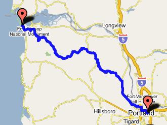
I left Portland by crossing the St. John's bridge and heading north on US 30. In the past, I took 30 all the way to Astoria. And one can do that, but it's not too fun (even though there's a generous shoulder) mainly because of a large volume of high-speed traffic. But the first 50 miles isn't too bad, and I turned off after 20, in Scappoose.
My latest favorite route to Astoria is via OR 202, which is a beautiful, quiet, flat road that goes through the coastal mountains of northwest Oregon at more or less river grade. The route basically starts in Vernonia, though, and one has three options for getting there. I've tried the road through Timber and OR 47, and both are pretty good options. By going to Scappoose, I was finally getting around to trying the third option: via the Scappoose-Vernonia road.
 I found it to be a fine route for riding. No shoulder and a stiff climb, of course, but not much traffic and fine scenery. Then the road flattened out, and these conditions continued all the way through Mist, Birkenfeld, and Jewell. Past the Jewell Wildlife Refuge, the road began climbing up to the summit of the coast range, and a couple miles later, I had a wide open downhill the rest of the way to camp.
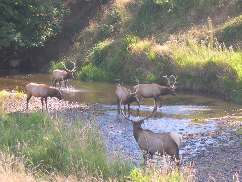 I wasn't quite at my destination, though, and I still had some exploring that I wanted to do. So rather than take 202 into Astoria, I turned a little early, onto the Olney Cutoff Road. This took me to Young's River Road, and up to Young's River Falls (which was a beautiful spot, well worth the detour). From the map, I wanted to turn onto Turner Creek Lane, but missed it because it wasn't signed. So I ended up on familiar ground heading into camp on the 101 business loop.
This made for a long (120 mile) day, but the trip could easily be done in two, and splits into nice 60 mile pieces if you overnight at either Vernonia City Park or Big Eddy County Park.
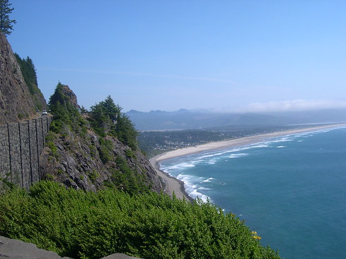
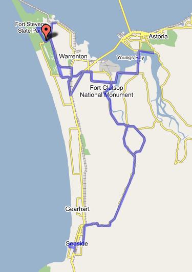 I spent Saturday socializing and generally having a good time. Much of that was done while riding. The back road route down to Seaside is wonderful, and beats the pants off the 101 route both in terms of scenery and traffic, with gentle, easy rollers and only a single climb to get you out of the river valley and over the hill into Seaside. Also, for next year's get together, I'm planning to lead a Saturday ride out to Young's River Falls, and up to the Astoria Column. (You can see some of the roads that my route will follow on the right side of the map here.) There's also some nice riding just within the park, which was a little more detail than I wanted to get into. Still in all, a day of social rides that totaled a surprising 80 miles when all was said and done.
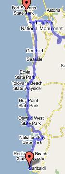 Sunday, I hung around and spent time with friends until around noon, when Mike Porter and I headed south. Our destination was Barview Jetty County Park, where there's a terrible campground with awesome hiker-biker sites. We basically just stayed on 101 the whole way, with a small side trip into Cannon Beach for lunch. Even with the late start, it was a very humane day at 50 miles.
If I had never ridden the coast before, or if we hadn't waited until 12 to start out, I would have taken some of the lower traffic, scenic backroads such as the Lewis & Clark River Road and the Miami River Road. As it stands, though, 101 on the Oregon Coast isn't too shabby in the southbound direction at least. ODOT favors that shoulder when they have to make a choice, and that the wind blows out of the northwest. So it's best to go south (feels like going downhill). The traffic is annoying in either direction.
 Finally, for my last day on the road, I continued on 101 to the outskirts of Tillamook, where I got on the Wilson River Loop/Latimer Road. That saved me from having to deal with downtown Tillamook, and dropped me off on highway 6. Highway 6 is another of my favorite routes to the coast -- it's beautiful, the pavement is good, the shoulders are fine, and the traffic is moderate. What recomends this route most to the beginner is that it consists of a single climb that summits at around 1600', and descends the rest of the way to the coast (or inland, if you are heading east).
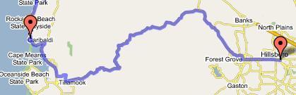 I took my time, stopping at the River's Edge Grill for an awesome chocolate chip cookie, exploring some intriguing rock stairs that turned out to lead up to a waterfall, and checking out the new Tillamook Forest Interpretive Center. After I crested the summit, I zipped down the other side, 9 miles to the junction with highway 8, and turned onto that. That took me through lovely rural Gales Creek Valley to Forest Grove, and from there I continued on 8 through the much less scenic portion that goes through Cornelius to Hillsboro. There, I got on the MAX, as I felt that riding through the western suburbs of Portland represented very little added value to my bike tour. Ending the ride at that point meant that the final day of my little tour weighed in at around 75 miles.
The whole ride:
 Here is a link to the pictures I took on the trip.
Here is a link to the loop in gmaps.
Here is a link to the local rides that I did around Fort Stevens. This might be of interest because it shows the back road to Seaside, and it shows how I would have gone into Fort Stevens if I hadn't missed the turn onto Turner Creek Lane.
posted by Michael at 12:26 PM
![]()

1 Comments:
Michael, I'm planning on riding from Portland to SF in the first two weeks of june. I'll be travelling with a friend and we are wondering about the best way to start our trip. We plan on leaving Portland and riding to Astoria on the first day. From a quick glance hwy. 30 looks the fastest, but that is almost never the best way! I'm fit and can handle "big miles" my partner can do 75-90 if pushed. What do you suggest for our route? I like the route you have described here. It looks and sounds great. Thank you Dylan
dylansnodgrass@gmail.com
Post a Comment
<< Home