9/9/2006 -- Klickitat Explorer 400k Brevet, 250 miles
People interested in this blog should either already know about randonneuring or get to know about it. Randonneuring is a wonderful non-competitive sport that involves riding one's bicycle a very long way. The original idea when the sport was devised was to demonstrate the distances that were attainable in reasonable lengths of time by the combination of a person's muscle power and a bicycle's mechanical advantage. To that end, randonneuring events (called randonnees or brevets) come in 200, 300, 400, and 600k lengths, and must be done within a specified time limit (typically around 15 kph). The rider who completes this cycle then has an opportunity to do a grande randonnee of 1000 or 1200k, if he is up for it. The randonneur has a card that he gets signed at various control points, which verifies that he has ridden the entire route.
The best part about randonneuring for me is the opportunity it gives me to share the road with fellow long haulers, even if our mis-matched capabilities and platforms mean that we only share our company for a limited time. There is a camaraderie and an esprit de corps that in many ways is even stronger than it is among racers, because of the massive challenge of the longer events and their non-competitive nature. Everyone who finishes is an equal, and riders take pride in keeping the DNQ rates as low as possible.
 Which brings us to the Klickitat Explorer 400k. This ride was organized by John Kramer, and was the second 400k event put on by the Oregon Randonneurs this year. In many ways, the 400k is considered to be the most difficult distance of all brevets in the regular series -- the distance is daunting for a single day, but the time control is 27 hours (not long enough to take a whole night off), so there is no way to avoid a fair chunk of night riding. (Obviously, the 1000k and 1200k events are daunting for the sheer magnitude of the distances involved.)
We set off from Bingen, Washington, at 5:00 AM under the silver light of a full moon. The wind was already freshening at my back, and after I wound the cranks up, I found myself flying low along Washington's SR-14. I've now ridden eastbound on both sides of the Columbia as it borders Oregon and Washington, and I must say (though it pains my provincial heart), SR-14 is vastly superior for cycling -- good shoulder, low traffic, beautiful views. Good surface for most of it (though we did have a couple stretches of chipseal). The only complaint was that the road is somewhat hilly, but even so there were no particularly difficult grades.
 I arrived at the first control 4 minutes after it opened, and so felt very good about my pace so far. I knew, though, that this was the flat section with a tailwind, and that the real work was ahead of me. This pace was going to be the exception today, rather than the rule. So I ate a ham sandwich and drank a pint of chocolate milk, and was on my way.
A few more flat, wind-assisted miles along the gorge, and then it was time to get down to work. The route turned north up Alderdale road, which started out winding up out of a creek cut, and then seemed to level off on a smooth plain. The road zig-zagged the to north and west, and soon I got a taste of what kind of wind I'd have to climb my way out of for the rest of the day. The wind didn't seem too bad, but yet I was working hard to little perceived effect. The plains that the road wound through were deceptive -- the lack of actual "hills" disguised the fact that I was climbing up a pretty good grade!
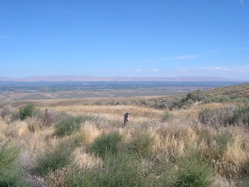 When I got to the top, I could see just how much elevation I had gained. Looking down, I could see the Yakima River Valley, and the town with the next control point, Mabton. I sped down the hill, checked in at the control, ate, replenished my water, and was soon on my way.
The next stretch of road was described as "flat as a pancake." A flat, but very rough pancake. With plenty of contrary wind. 19 miles to Toppenish seemed to drag on interminably. Then I turned southwest on US 97, to tackle the major climb of the day.
97 between Toppenish and the top of Satus Pass wasn't a bad road, but there was plenty of traffic and a shoulder that came and went. The road followed a creek grade through dry hills typical of the northwest United States east of the Cascades. The ground around the creek was a lush oasis, and climbed very gradually. But about 5 miles from the top, the grade increased, and it was all business the rest of the way up. After a brief descent, I pulled off the road at Brooks Campground to check into the next control.
A quick break, and I got to enjoy the fruits of my labors, as I had a fairly easy and quick descent (though still impeded by the headwind) down the other side of the pass to Goldendale. In Goldendale, the route turned west, and spent about 20 miles on some pretty unpleasant rollers. Normally, I'm way cool with rollers, but the headwind was preventing me from getting up the momentum I need to really tame them.
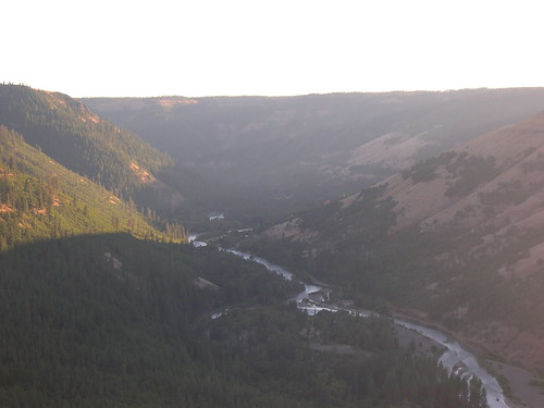 Then, as all things must when you keep pedaling, the rollers ended, and I found myself at the top of the Klickitat River Gorge. An absolutely stunning, surprising sight that just took my breath away when it emerged around the corner. I was incredibly grateful to have been strong enough to get there before the daylight ended, both to be able to see it, and to have the light for the twisty descent down to the river.
Of course, what goes down, must come up, but aside from a short, stiff section just on the other side of the river, the climb back out was surprisingly painless. I soon found myself at the final control in Glenwood, near the base of Mt. Adams. I took a break there, letting my legs recover and taking in some fuel for the home stretch, and when I emerged to tackle the last 30 miles, the dark of night had fallen.
Fortunately, the twin E6 lamps on the front of my Aero lit up the road with aplomb, and I was able to navigate the dark country roads unerringly. There was very little to see, naturally, but at one point I did look towards the horizon on my right, and noticed an owl flying along with me against the backlit sky. This final leg featured a heaping helping of elevation loss, and I got the bracing experience of a fairly high-speed descent down to BZ Corner. Then it was just a matter of winding through White Salmon, down the hill, and back to the start point for a 7up and a nice hot bowl of ravioli, finishing 17 hours and 1 minute after I started.
I've put up some pictures from the ride on my flickr site.
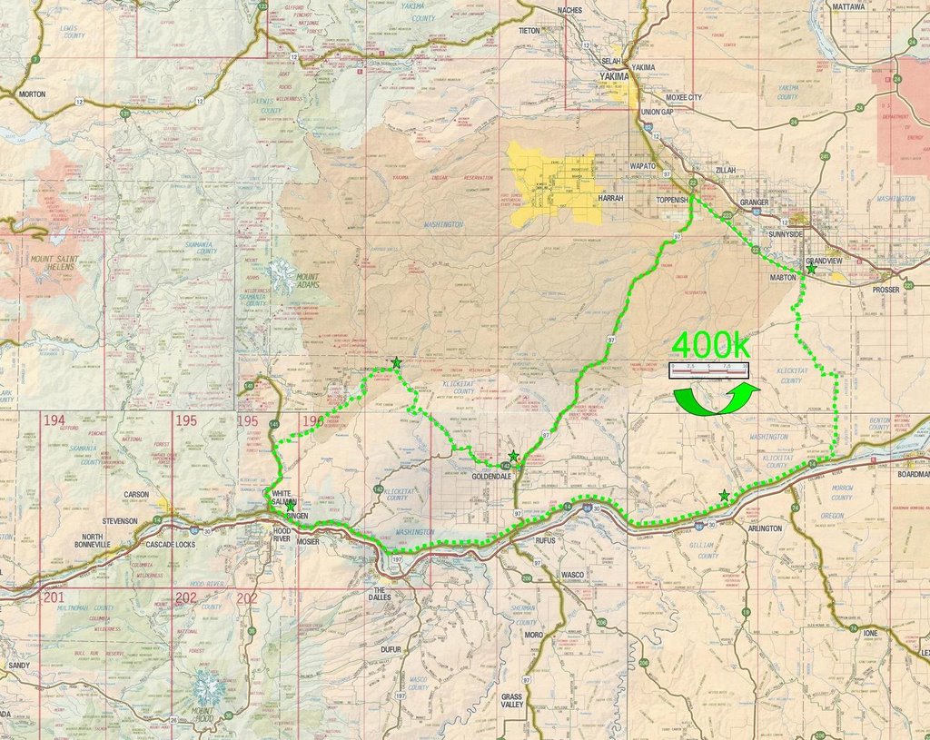
I haven't done a google map of the route, because John Kramer did the nice jpeg map that I've attached. If anyone needs more detail than that provides, I believe there is a cue sheet on the Oregon Randonneurs site.
The best part about randonneuring for me is the opportunity it gives me to share the road with fellow long haulers, even if our mis-matched capabilities and platforms mean that we only share our company for a limited time. There is a camaraderie and an esprit de corps that in many ways is even stronger than it is among racers, because of the massive challenge of the longer events and their non-competitive nature. Everyone who finishes is an equal, and riders take pride in keeping the DNQ rates as low as possible.
 Which brings us to the Klickitat Explorer 400k. This ride was organized by John Kramer, and was the second 400k event put on by the Oregon Randonneurs this year. In many ways, the 400k is considered to be the most difficult distance of all brevets in the regular series -- the distance is daunting for a single day, but the time control is 27 hours (not long enough to take a whole night off), so there is no way to avoid a fair chunk of night riding. (Obviously, the 1000k and 1200k events are daunting for the sheer magnitude of the distances involved.)
We set off from Bingen, Washington, at 5:00 AM under the silver light of a full moon. The wind was already freshening at my back, and after I wound the cranks up, I found myself flying low along Washington's SR-14. I've now ridden eastbound on both sides of the Columbia as it borders Oregon and Washington, and I must say (though it pains my provincial heart), SR-14 is vastly superior for cycling -- good shoulder, low traffic, beautiful views. Good surface for most of it (though we did have a couple stretches of chipseal). The only complaint was that the road is somewhat hilly, but even so there were no particularly difficult grades.
I arrived at the first control 4 minutes after it opened, and so felt very good about my pace so far. I knew, though, that this was the flat section with a tailwind, and that the real work was ahead of me. This pace was going to be the exception today, rather than the rule. So I ate a ham sandwich and drank a pint of chocolate milk, and was on my way.A few more flat, wind-assisted miles along the gorge, and then it was time to get down to work. The route turned north up Alderdale road, which started out winding up out of a creek cut, and then seemed to level off on a smooth plain. The road zig-zagged the to north and west, and soon I got a taste of what kind of wind I'd have to climb my way out of for the rest of the day. The wind didn't seem too bad, but yet I was working hard to little perceived effect. The plains that the road wound through were deceptive -- the lack of actual "hills" disguised the fact that I was climbing up a pretty good grade!
When I got to the top, I could see just how much elevation I had gained. Looking down, I could see the Yakima River Valley, and the town with the next control point, Mabton. I sped down the hill, checked in at the control, ate, replenished my water, and was soon on my way.The next stretch of road was described as "flat as a pancake." A flat, but very rough pancake. With plenty of contrary wind. 19 miles to Toppenish seemed to drag on interminably. Then I turned southwest on US 97, to tackle the major climb of the day.
97 between Toppenish and the top of Satus Pass wasn't a bad road, but there was plenty of traffic and a shoulder that came and went. The road followed a creek grade through dry hills typical of the northwest United States east of the Cascades. The ground around the creek was a lush oasis, and climbed very gradually. But about 5 miles from the top, the grade increased, and it was all business the rest of the way up. After a brief descent, I pulled off the road at Brooks Campground to check into the next control.
A quick break, and I got to enjoy the fruits of my labors, as I had a fairly easy and quick descent (though still impeded by the headwind) down the other side of the pass to Goldendale. In Goldendale, the route turned west, and spent about 20 miles on some pretty unpleasant rollers. Normally, I'm way cool with rollers, but the headwind was preventing me from getting up the momentum I need to really tame them.
Then, as all things must when you keep pedaling, the rollers ended, and I found myself at the top of the Klickitat River Gorge. An absolutely stunning, surprising sight that just took my breath away when it emerged around the corner. I was incredibly grateful to have been strong enough to get there before the daylight ended, both to be able to see it, and to have the light for the twisty descent down to the river.Of course, what goes down, must come up, but aside from a short, stiff section just on the other side of the river, the climb back out was surprisingly painless. I soon found myself at the final control in Glenwood, near the base of Mt. Adams. I took a break there, letting my legs recover and taking in some fuel for the home stretch, and when I emerged to tackle the last 30 miles, the dark of night had fallen.
Fortunately, the twin E6 lamps on the front of my Aero lit up the road with aplomb, and I was able to navigate the dark country roads unerringly. There was very little to see, naturally, but at one point I did look towards the horizon on my right, and noticed an owl flying along with me against the backlit sky. This final leg featured a heaping helping of elevation loss, and I got the bracing experience of a fairly high-speed descent down to BZ Corner. Then it was just a matter of winding through White Salmon, down the hill, and back to the start point for a 7up and a nice hot bowl of ravioli, finishing 17 hours and 1 minute after I started.
I've put up some pictures from the ride on my flickr site.
I haven't done a google map of the route, because John Kramer did the nice jpeg map that I've attached. If anyone needs more detail than that provides, I believe there is a cue sheet on the Oregon Randonneurs site.
posted by Michael at 10:12 AM
![]()

0 Comments:
Post a Comment
<< Home