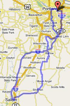
8/27/2006 to 8/28/2006 -- Salem, 130 miles
 While the coast, the gorge, and Mt. Hood represent the glamour destinations for Portland cyclotouristes, Salem is an afterthought at best. At first, it doesn't make sense: the ride is an easy, flat 65 miles, there are plenty of beautiful and low traffic roads from Portland down to Salem, and the town is large enough to provide all of the services that a bicycle traveler could want. So why don't Portland cyclists frequently hear of two or three day excursions taken by riders down the valley to our state capitol?
The answer is very simple: Salem provides no good answer to the question, why bother? Generally, there really isn't any good reason to make the trip. Salem doesn't have any particular attraction, and while the ride down the valley is first rate, actually riding through the outskirts of town consists of your typical 5 lane highways and strip malls. Earlier this summer, though, I got wind of a concert that would take place at the state fair that I thought would be really fun to see (The Decemberists, The Violent Femmes, and Cake). So I brought up the idea of taking the weekend and riding down there with my friend Jeme, and we made our plans.
Let's go to the fair!
 Since Jeme is an upright rider, and since this was his first loaded bike trip, I thought that it would be good to show some solidarity with him, and to ride a bike that would let us be relatively evenly matched. For this reason, I selected my Rivendell Atlantis for the trip.
Jeme and I got a late start, and proceeded south on the Oaks Bottom bike path under the warming sun. We found our way through Sellwood and Milwaukie to River Road, and took that to Oregon City. From there, we crossed the Willamette River to West Linn, and took Willamette Falls Road through the historic downtown and around Pete's Mountain to Turner Road, which we took over the hill's shoulder. Turning onto Mountain Road, we had a fun set of descending rollers all the way down to the Canby Ferry, which took us back across the Willamette River to the town of Canby.
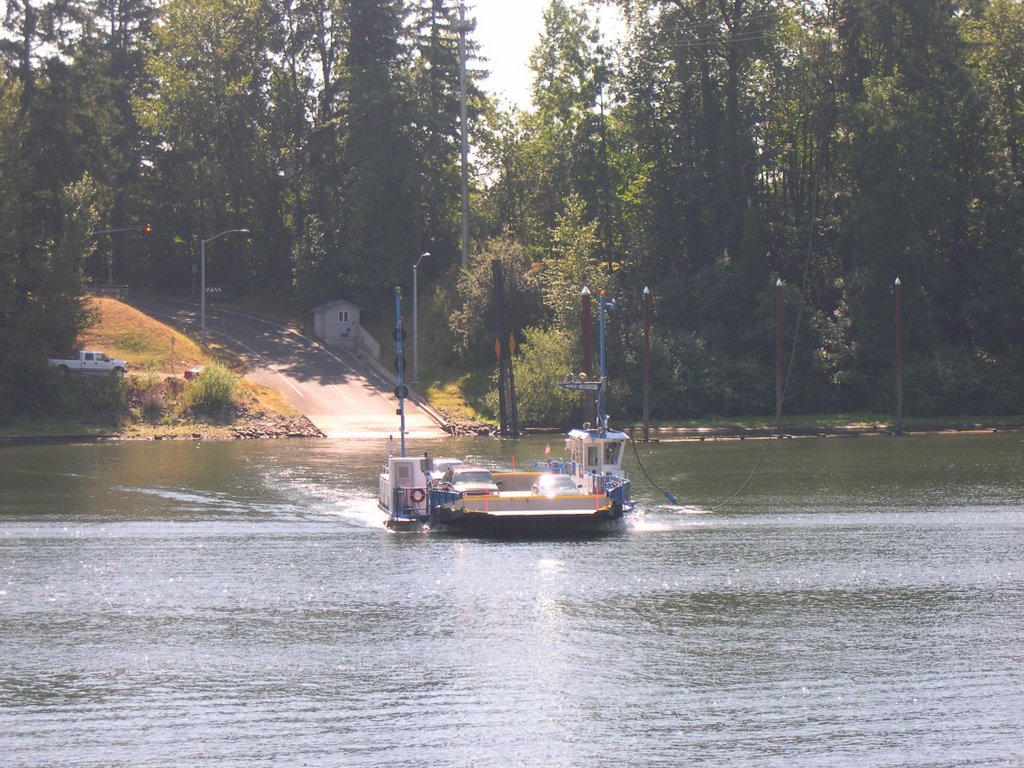 From Canby we went south, through country that I knew well from day rides that I've done with my friends Bruce and Bill, who live in the area. We pedalled through Lone Elder, and took secondary roads such as Gribble and Zimmerman to Meridian Road, which runs up the spine of Elliott Prairie from Aurora to Silverton. Meridian is a wonderful road, with long lines of sight, little traffic, easy grades, and nicely spaced opportunities to buy refreshments at Whiskey Hill and Monitor.
In the charming little town of Silverton we took a rest break in the city park. Then we headed southwest out of town past the Oregon Garden, but I had us turn west one road too soon, and we found ourselves on the Silverton-Salem Highway. I had hoped to take secondary roads on this leg, but it was the part of the ride that I was least familiar with. The main road was fine, though, with plenty of shoulder and traffic that was reasonably light (6 cars per minute or so) and not overly fast. It also took us almost right to the doorstep of my friend Keith's house, in whose yard Jeme and I were to camp.
The fair was something of an alien cultural experience, and I got more than enough of it in the 90 minutes we had to look around before the show. The concert was great fun -- The Decemberist's new album should be excellent, judging from their new material, and Cake was in fine form. It was a little painful to watch the poor Femmes play the same 10 songs they've been playing for the last 25 years, though.
 The next morning we packed up and headed north on Cherry and then River Road out of Salem (different River Road). This took us very cleanly out of Salem and then Keizer, and soon we found ourselves on French Prairie, rolling through fields of hops. The wind was contrary, so I let Jeme sit on my wheel all the way up to Champoeg park -- the birthplace of Oregon's state government. It was a straight shot all the way up from Salem.
We took a moment in the park to enjoy the Willamette River, and then took the park's bike path through the woods to Butteville. From Butteville we proceeded on Arndt and Knight's Bridge Roads into Canby, a route which was very familiar to me from the Portland Wheelmen's Spring Century. We got onto Territorial in Canby, rode to 99E, and took South End Road over the hill back into Oregon City. Just past Oregon City, we crossed the Clackamas River, and Jeme decided that the water simply looked too inviting to pass up, so I bid him farewell, and proceeded up the I-205 bike path back home, concluding a fun trip.
This expedition is a great illustration of the best options for accessing the Willamette Valley from East Portland. The first step is to get to Oregon City, and my favorite ways to do that are to take the Oaks Bottom Path and River Road, or the I-205 path. (Another option would be to take Terwilliger from downtown and 43 from Lake Oswego.) From Oregon City, Canby is a logical next waypoint, and both the West Linn-Turner Road-Canby Ferry route (for the scenery) and the South End-Territorial Road route (for speed, if you can manage the steep climb out of Oregon City) are good ways to get there. Finally, to go further south, you almost can't go wrong with any secondary road in the valley, but for my money, Meridian Road and French Prairie Road/River Road stand out because of their directness and the sheer amount of ground they cover.
Here is a link to the route on the google maps pedometer.
Here is a link to my photos on flickr.
posted by Michael at 9:04 PM
![]()

1 Comments:
Your site was very informative as my I am considering biking to Salem with my friend.
Do you have written directions that you could post so other people could attempt this adventure?
Thank you!
Post a Comment
<< Home