Long Hauls: To Do List
UPDATED: Added the Nestucca River Road
I love riding brevets. It's been especially nice in this my rookie season, as I was exposed to each of the routes that I've done for the first time, and there's nothing better than riding a new road, in my book. I may get less of that thrill next year as I do some of the same routes for the second time in the '07 series. That's fine; I am looking forward to revisiting Susan France's wonderful Three Capes route, and I certainly would have no problem with re-doing John Kramer's Klickitat Explorer route (though I don't believe that it's going to be offered next year.)
However, I've got to have that thrill of discovery in my riding, at least part of the time. The exploration of new roads and new areas is a huge part of why I started riding the long haul in the first place. I had ridden many of the interesting roads close to home, so I had to pedal farther and farther afield to find new routes. Pretty soon, it was for the sake of riding the unridden road that was itself the motivation for going out on the ride. So I keep staring at maps, and thinking to myself, "I wonder if that would be a nice road to bike on?" Such was the impetus that pushed me to do my Mt. Hood circumnavigation, my Longview ride, Old Man Pass, Detroit Lake, and High Rock (which I'll write up soon).
Fortunately, I live in an area with plenty of opportunities to explore, and my docket keeps getting new fodder for rides. Here are some of the roads that I'm looking forward to pedaling in the next year.
Forest Service Road 45
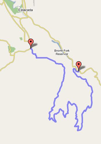
 Here's the type of road that my Atlantis was made for, and the type of road that I had in mind when I got the bike. It starts off paved, at the Clackamas River, and goes right up the hillside. The pavement soon ends, and the road winds through the Cascade foothills. After a few miles, it passes a trailhead for the short hike up to Memaloose Lake. That's as far as I've been, and it's very pretty country. From there, it's possible to do a loop that takes you back down to Estacada. When the snow melts around the Clackamas River area, I'll look for a Saturday to saddle up the Atlantis and ride out to Estacada, do the loop, and ride back into town on Springwater Road.
Cherryville Road
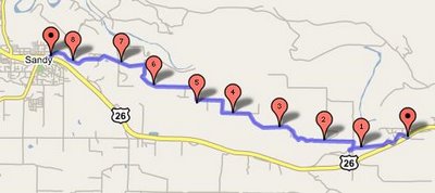 I've written up the Barlow Road route up to Mt. Hood, and I love that route. But sometimes, making that climb up the Devil's Backbone to get out of the Sandy River valley just seems like a lot of work. And in those times, one might be tempted to ride highway 26. If one takes Sleepy Hollow Road to 26, and rides up the highway for just a mile or so, Cherryville Road offers another possibility, one that features far less traffic. I've never ridden it, however, but it is an ideal candidate to be part of a medium-length day ride from Portland. I'll have to get on William Tell out and give it a look, but checking the elevation profile on google maps, it looks like it might be pretty hilly -- certainly, that climb up to Sandy on Ten Eyck is kinda brutal.
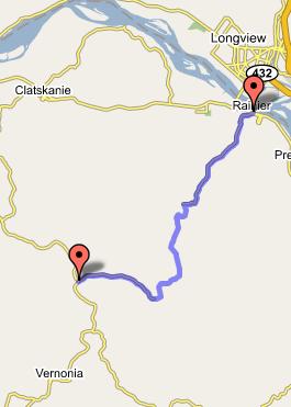
Apiary Road
 The roads around Vernonia have been a big discovery for me in the last 15 months or so. There is some wonderful scenic riding to be in the Nehalem River valley, through the coast range. Little traffic, forests and farmlands, and a couple good options for rest stops in the area. The last couple times I rode to Astoria, I took highway 202.
Before that, I took highway 30. So, staring at the map, I had to wonder what the country in between the two routes was like. One more prominent road in the intervening country is Apiary Road. I am told that it is paved for its whole length, but I'd like to find out for myself, and to see what kind of hills and scenery it features.
The neat thing about the road is that if it is reasonably navigable, it closes a couple of loops. Ride Apiary to Fern Hill, and it'll take you down to Rainier, Oregon. From Rainier, you can ride back into Portland on Highway 30, or you could cross the Lewis & Clark bridge, and take my Washington route down through Vancouver. Or, you could stay on the ridge above the river, connect up to Old Highway 30, and explore...
Alston-Mayger Road
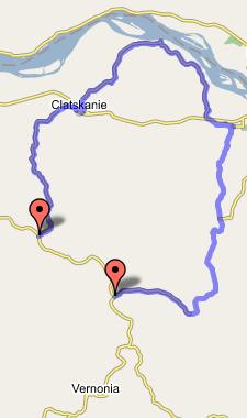 Before I discovered the 202 route to Astoria, I wondered if there were any good side roads that would take me off of highway 30 and provide some relief, if only for part of the trip. The Alston-Mayger Road looked like a fantastic candidate -- not only could I nix several miles of traffic in the middle of the journey, it also neatly circumvented a pretty big climb above Clatskanie. I never got around to checking it out, but I'm still curious about it. It should be possible to ride out to Scappoose, take the Scappoose-Vernonia Road over the hills, turn onto Apiary Road, take that up to the Alston-Mayger Road, then take the Clatskanie-Mist Road back to 202, and from there pick any of three routes back into the Portland area. I think that would make a pretty nice long day, with a respectable amount of climbing.
Nestucca River Road
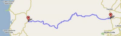 How could I forget the Nestucca River Road! A by all accounts beautiful route from the coast to the valley. No traffic, coastal forests, campgrounds along the way, and the reasonable grades of the coast range. I'm definitely looking forward to checking this one out, most likely as part of a day loop that starts at the Hillsboro MAX terminus, goes out to the coast on Highway 6, over Cape Lookout, and picks up the route after taking Sand Lake road in to 101. Then maybe if it's everything it's cracked up to be, I'll return someday as part of a loaded expedition.
Here are links to more detailed maps of these roads, in gmaps:
Forest Road 45
Cherryville Road
Apiary Road
Alston-Mayger Road
Nestucca River Road
I love riding brevets. It's been especially nice in this my rookie season, as I was exposed to each of the routes that I've done for the first time, and there's nothing better than riding a new road, in my book. I may get less of that thrill next year as I do some of the same routes for the second time in the '07 series. That's fine; I am looking forward to revisiting Susan France's wonderful Three Capes route, and I certainly would have no problem with re-doing John Kramer's Klickitat Explorer route (though I don't believe that it's going to be offered next year.)
However, I've got to have that thrill of discovery in my riding, at least part of the time. The exploration of new roads and new areas is a huge part of why I started riding the long haul in the first place. I had ridden many of the interesting roads close to home, so I had to pedal farther and farther afield to find new routes. Pretty soon, it was for the sake of riding the unridden road that was itself the motivation for going out on the ride. So I keep staring at maps, and thinking to myself, "I wonder if that would be a nice road to bike on?" Such was the impetus that pushed me to do my Mt. Hood circumnavigation, my Longview ride, Old Man Pass, Detroit Lake, and High Rock (which I'll write up soon).
Fortunately, I live in an area with plenty of opportunities to explore, and my docket keeps getting new fodder for rides. Here are some of the roads that I'm looking forward to pedaling in the next year.
Forest Service Road 45
 Here's the type of road that my Atlantis was made for, and the type of road that I had in mind when I got the bike. It starts off paved, at the Clackamas River, and goes right up the hillside. The pavement soon ends, and the road winds through the Cascade foothills. After a few miles, it passes a trailhead for the short hike up to Memaloose Lake. That's as far as I've been, and it's very pretty country. From there, it's possible to do a loop that takes you back down to Estacada. When the snow melts around the Clackamas River area, I'll look for a Saturday to saddle up the Atlantis and ride out to Estacada, do the loop, and ride back into town on Springwater Road.
Cherryville Road
 I've written up the Barlow Road route up to Mt. Hood, and I love that route. But sometimes, making that climb up the Devil's Backbone to get out of the Sandy River valley just seems like a lot of work. And in those times, one might be tempted to ride highway 26. If one takes Sleepy Hollow Road to 26, and rides up the highway for just a mile or so, Cherryville Road offers another possibility, one that features far less traffic. I've never ridden it, however, but it is an ideal candidate to be part of a medium-length day ride from Portland. I'll have to get on William Tell out and give it a look, but checking the elevation profile on google maps, it looks like it might be pretty hilly -- certainly, that climb up to Sandy on Ten Eyck is kinda brutal.
Apiary Road
 The roads around Vernonia have been a big discovery for me in the last 15 months or so. There is some wonderful scenic riding to be in the Nehalem River valley, through the coast range. Little traffic, forests and farmlands, and a couple good options for rest stops in the area. The last couple times I rode to Astoria, I took highway 202.
Before that, I took highway 30. So, staring at the map, I had to wonder what the country in between the two routes was like. One more prominent road in the intervening country is Apiary Road. I am told that it is paved for its whole length, but I'd like to find out for myself, and to see what kind of hills and scenery it features.
The neat thing about the road is that if it is reasonably navigable, it closes a couple of loops. Ride Apiary to Fern Hill, and it'll take you down to Rainier, Oregon. From Rainier, you can ride back into Portland on Highway 30, or you could cross the Lewis & Clark bridge, and take my Washington route down through Vancouver. Or, you could stay on the ridge above the river, connect up to Old Highway 30, and explore...
Alston-Mayger Road
 Before I discovered the 202 route to Astoria, I wondered if there were any good side roads that would take me off of highway 30 and provide some relief, if only for part of the trip. The Alston-Mayger Road looked like a fantastic candidate -- not only could I nix several miles of traffic in the middle of the journey, it also neatly circumvented a pretty big climb above Clatskanie. I never got around to checking it out, but I'm still curious about it. It should be possible to ride out to Scappoose, take the Scappoose-Vernonia Road over the hills, turn onto Apiary Road, take that up to the Alston-Mayger Road, then take the Clatskanie-Mist Road back to 202, and from there pick any of three routes back into the Portland area. I think that would make a pretty nice long day, with a respectable amount of climbing.
Nestucca River Road
 How could I forget the Nestucca River Road! A by all accounts beautiful route from the coast to the valley. No traffic, coastal forests, campgrounds along the way, and the reasonable grades of the coast range. I'm definitely looking forward to checking this one out, most likely as part of a day loop that starts at the Hillsboro MAX terminus, goes out to the coast on Highway 6, over Cape Lookout, and picks up the route after taking Sand Lake road in to 101. Then maybe if it's everything it's cracked up to be, I'll return someday as part of a loaded expedition.
Here are links to more detailed maps of these roads, in gmaps:
Forest Road 45
Cherryville Road
Apiary Road
Alston-Mayger Road
Nestucca River Road
posted by Michael at 8:59 PM
![]()

4 Comments:
Apiary road is paved. It is about the same quality as 202 from Vernonia to Mist... not much for shoulders but less traffic than 202. If you follow it all the way to Hwy. 30, you will be at the top of the big hill west of the Lewis and Clark bridge. It should be a nice scenic ride.
Bill
I have been thinking about riding Nestucca River road for about a year. Last Thanksgiving, I got in my Xterra and drove it; I would have ridden it but there was about 2 feet of snow on it at the time. It is a great rode - but not traffic-free by any means. And the cars on it are mostly pick-up trucks. There is a fair amount of hunting and fishing going on up there, and folks do live on the east side of the range. Anyway - I'm game for the ride if you are looking for a partner for the trip.
dr
David-
Thanks very much for the information and the offer! I would really enjoy your company for a Nestucca expedition. Probably something to do in the spring. I could ride my usual randonneuring bike, but the tires only go up to 28mm. I could ride my Atlantis, but I'm not terribly quick on it, or too well conditioned for a 150 mile ride on an upright.
HI Guys- I've ridden the Nestucca twice. Once with one friend and the next summer (07) with 9 folks loaded down. We took the max to Hillsboro and then camped on the west side of the coast range (Dovre I think?) along the river. On day two we cruised to Lincoln city and stayed in our rented house. It's a great way to spend a 3 day weekend.
On the second trip with 9 folks you can really see who is in good shape. There's about 15 miles of intense hill after Carlton. We rolled into camp in the afternoon in 3 separate groups. The first two riders were about 3 hours ahead of the last 3 riders.
I highly recommend this route- we went mid summer (end of July- happy bday to me!) and there was very little traffic and it's all paved except for about 3 miles. Make sure to bring water! There's no water source out of Carlton until you are on the west side and it gets hot in the clear cuts.
Post a Comment
<< Home